javascript游戏开发之《三国志曹操传》零部件开发(四)用地图块拼成大地图 |
|
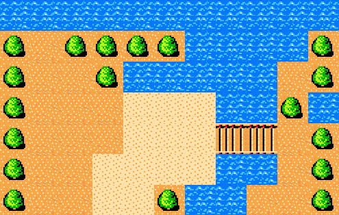
小时候我们玩过拼图游戏,是用自己的手去拼的 。今天我们来研究研究用javascript来拼图 。同样是拼图,但用js拼图要比用手拼图麻烦多了,因此以后我要把它优化成引擎 。 一、前言 以上是一段导语,话不扯远,对《三国志曹操传》熟悉的玩家知道,《三国志曹操传》的地图是由小地图块拼成的,那要实现它就和导语说得一样:很麻烦 。不过即使麻烦也是一门技术,因此在此分享给大家,希望大家喜欢 。 二、代码讲解 今天我要换换讲解方式,先不给代码,我们先来想想原理 。现在,假如你有一幅图片,把它裁开成若干份,并打乱 。现在如果让你用js把他们组织起来,如何做呢?先不说图的顺序,首先来看把它们弄在一起就很难了 。这时我减少难度,给你几个选择:A.用margin慢慢调 B.用数组把它们排列好 C.放弃 在这道题中,选A是很不明智的,选C就代表你也拿不定主意 。看来选B是最好的 。既然都告诉大家用数组,那就先上代码吧 。免得消磨大家兴致 。 复制代码 代码如下: /* *Prompt: *If you want to add hurdle, find string: "{{Add hurdle above." and "{{After add hurdle, add the hurdle to the vector above." please. *If you want to add or change type of grid, find string: "{{Add new grid above.". *If you want to change position of map, please find string: "{{Change map margin above.". *If the icon of crid is changed, you have to change the size of icon. Find "{{Change icon size above." to change size. */ //Map of hurdle or military or resource. var vView = []; /*Remarks: *L: land *S: sea *R: river *W: swamp *A: lawn *B: bridge *H: house *h: hospital *w: warehouse *b: bourse *M: military academy *m: military factories *r: research Center *P: port *D: dock *s: Shipyard */ var mScene = { L: [./land.png, 陆地] , S: [./sea.png, 河流] , T: [./tree.png, 树木] , B: [./bridge.png, 桥] , C: [./beach.png, 沙滩] }; //{{Add new grid above. var mCurrent = { Margin: { left: -1 , top: -1 , right: -1 , bottom: -1 } , Position: { X: -1 , Y: -1 } , Type: NONE }; var mTitle = {}; var sHurdleONE = S,S,S,S,S,S,S,S,S,S,S + ;T,L,T,T,T,T,S,S,S,S,T + ;T,L,L,T,S,S,S,S,S,L,T + ;T,L,L,L,C,C,C,S,S,T,S + ;T,L,L,L,C,C,C,B,B,L,T + ;T,L,L,C,C,C,C,S,S,L,T + ;T,L,L,C,C,T,S,S,L,L,T //{{Add hurdle above. var vHurdles = [sHurdleONE]; //{{After add hurdle, add the hurdle to the vector above. function _createGrid(nWidthBasic, nHeightBasic, nPicWidth, nPicHeight, cType, mMargin) { var mCoordMember = { left: nWidthBasic , top: nHeightBasic , right: nWidthBasic + nPicWidth , bottom: nHeightBasic + nPicHeight }; var mPositionMember = { X: (mCoordMember.left - mMargin.x) / nPicWidth , Y: (mCoordMember.top - mMargin.y) / nPicHeight }; var mItem = { Coord: mCoordMember , Position: mPositionMember , Type: cType }; return mItem; } function _loadHurdle(sHurdle) { var nBasic = 0; var nWidthBasic = nBasic; //margin-left. var nHeightBasic = 0; //margin-top. //{{Change map margin above. var nPicWidth = 45; //Picture width is nBasic. var nPicHeight = 45; //Picturn height is nHeightBasic. //{{Change icon size above. var nSub; var nRow; var nCol; var v = sHurdle.split(;); var vRec = []; for(nSub = 0; nSub < v.length; nSub++){ var vCrid = v[nSub].split(,); vRec[vRec.length] = vCrid; } for(nRow = 0; nRow < vRec.length; nRow++){ var vCol = vRec[nRow]; for(nCol = 0; nCol < vCol.length; nCol++){ var cType = vCol[nCol]; var mMargin = {x: nBasic, y: nBasic}; vView[vView.length] = _createGrid(nWidthBasic, nHeightBasic, nPicWidth, nPicHeight, cType, mMargin); nWidthBasic += nPicWidth; } nHeightBasic += nPicHeight; nWidthBasic = nBasic; } } //Show map with vector vView. function _showMap(sID) { var xDiv=document.getElementById(sID); var xGrid; var xImg; var nTop = 0; var nSub; var sIdPrefix = ID_IMG_NUM_; var sIdGrid = ID_A_NUM_; for(nSub = 0; nSub < vView.length; nSub++){ var mGrid = vView[nSub]; if(mGrid){ var xMargin = mGrid.Coord; var cType = mGrid.Type; var xProper = mScene[cType]; if(xProper){ xGrid = document.createElement(a); xImg = document.createElement(img); xImg.style.position = absolute; xImg.style.marginLeft = xMargin.left; xImg.style.marginTop = xMargin.top; xImg.src = xProper[0]; xImg.style.border = 0px solid #000000; xImg.id = sIdPrefix + nSub; xImg.style.width = 45; xImg.style.height = 45; xImg.style.display = block; xGrid.onclick = function(e){ var xCurrentGrid = e.target; var sId = xCurrentGrid.id; var nIdAsSub = parseInt(sId.substring(sIdPrefix.length, sId.length)); mCurrent = vView[nIdAsSub]; if(!mCurrent){ alert("Error 0004."); } }; xGrid.title = xProper[1] + ( + parseInt(mGrid.Position.X) + , + parseInt(mGrid.Position.Y+2) + ); xGrid.id = sIdGrid + nSub; xGrid.appendChild(xImg); xDiv.appendChild(xGrid); }else{ alert("Error: 0003."); } }else{ alert("Error: 0002."); } } } //Show map of hurdle. function _showHurdle(nHurdle) { if(vHurdles[nHurdle - 1]){ _loadHurdle(vHurdles[nHurdle - 1]); _showMap(ID_DIV_BATTLEFIELD); }else{ alert("Error: 0001."); } } 看看,这点程序就用了195行,而且这还是一张地图,看来还很有点麻烦哦 。没关系,慢慢解释 。 首先还是把素材放在这里:
复制代码 代码如下: var mScene = { L: [./land.png, 陆地] , S: [./sea.png, 河流] , T: [./tree.png, 树木] , B: [./bridge.png, 桥] , C: [./beach.png, 沙滩] }; //{{Add new grid above. var mCurrent = { Margin: { left: -1 , top: -1 , right: -1 , bottom: -1 } , Position: { X: -1 , Y: -1 } , Type: NONE }; var mTitle = {}; var sHurdleONE = S,S,S,S,S,S,S,S,S,S,S + ;T,L,T,T,T,T,S,S,S,S,T + ;T,L,L,T,S,S,S,S,S,L,T + ;T,L,L,L,C,C,C,S,S,T,S + ;T,L,L,L,C,C,C,B,B,L,T + ;T,L,L,C,C,C,C,S,S,L,T + ;T,L,L,C,C,T,S,S,L,L,T //{{Add hurdle above. var vHurdles = [sHurdleONE]; //{{After add hurdle, add the hurdle to the vector above. 首先我把S,T,B,C,L定义好,使S代表河流,T代表树木,B代表桥,C代表沙滩,L代表陆地 。var mCurrent后面有用,暂不解释 。然后是var mTitle,这个专门是用来显示title的,所以也不解释了 。关键是在下: 复制代码 代码如下: var sHurdleONE = S,S,S,S,S,S,S,S,S,S,S + ;T,L,T,T,T,T,S,S,S,S,T + ;T,L,L,T,S,S,S,S,S,L,T + ;T,L,L,L,C,C,C,S,S,T,S + ;T,L,L,L,C,C,C,B,B,L,T + ;T,L,L,C,C,C,C,S,S,L,T + ;T,L,L,C,C,T,S,S,L,L,T 这段代码就是把定义好的S,T,B,C,L连在一起的核心 。后面只用定义S,T,B,C,L的宽度高度定义就能把它们连成一块 。并且只要把它们在数组里的位置调一调就能改变样式 。 接下来为了能切换地图,我们把第一张地图放进了数组: 复制代码 代码如下: var vHurdles = [sHurdleONE]; //{{After add hurdle, add the hurdle to the vector above. 如果以后加了地图,只用把地图所属的数组名加到vHurdles数组就可以了,调用是就可以直接写对应下标 。 样式设置在下: 复制代码 代码如下: function _createGrid(nWidthBasic, nHeightBasic, nPicWidth, nPicHeight, cType, mMargin) { var mCoordMember = { left: nWidthBasic , top: nHeightBasic , right: nWidthBasic + nPicWidth , bottom: nHeightBasic + nPicHeight }; var mPositionMember = { X: (mCoordMember.left - mMargin.x) / nPicWidth , Y: (mCoordMember.top - mMargin.y) / nPicHeight }; var mItem = { Coord: mCoordMember , Position: mPositionMember , Type: cType }; return mItem; } function _loadHurdle(sHurdle) { var nBasic = 0; var nWidthBasic = nBasic; //margin-left. var nHeightBasic = 0; //margin-top. //{{Change map margin above. var nPicWidth = 45; //Picture width is nBasic. var nPicHeight = 45; //Picturn height is nHeightBasic. //{{Change icon size above. var nSub; var nRow; var nCol; var v = sHurdle.split(;); var vRec = []; for(nSub = 0; nSub < v.length; nSub++){ var vCrid = v[nSub].split(,); vRec[vRec.length] = vCrid; } for(nRow = 0; nRow < vRec.length; nRow++){ var vCol = vRec[nRow]; for(nCol = 0; nCol < vCol.length; nCol++){ var cType = vCol[nCol]; var mMargin = {x: nBasic, y: nBasic}; vView[vView.length] = _createGrid(nWidthBasic, nHeightBasic, nPicWidth, nPicHeight, cType, mMargin); nWidthBasic += nPicWidth; } nHeightBasic += nPicHeight; nWidthBasic = nBasic; } } //Show map with vector vView. function _showMap(sID) { var xDiv=document.getElementById(sID); var xGrid; var xImg; var nTop = 0; var nSub; var sIdPrefix = ID_IMG_NUM_; var sIdGrid = ID_A_NUM_; for(nSub = 0; nSub < vView.length; nSub++){ var mGrid = vView[nSub]; if(mGrid){ var xMargin = mGrid.Coord; var cType = mGrid.Type; var xProper = mScene[cType]; if(xProper){ xGrid = document.createElement(a); xImg = document.createElement(img); xImg.style.position = absolute; xImg.style.marginLeft = xMargin.left; xImg.style.marginTop = xMargin.top; xImg.src = xProper[0]; xImg.style.border = 0px solid #000000; xImg.id = sIdPrefix + nSub; xImg.style.width = 45; xImg.style.height = 45; xImg.style.display = block; xGrid.onclick = function(e){ var xCurrentGrid = e.target; var sId = xCurrentGrid.id; var nIdAsSub = parseInt(sId.substring(sIdPrefix.length, sId.length)); mCurrent = vView[nIdAsSub]; if(!mCurrent){ alert("Error 0004."); } }; xGrid.title = xProper[1] + ( + parseInt(mGrid.Position.X) + , + parseInt(mGrid.Position.Y+2) + ); xGrid.id = sIdGrid + nSub; xGrid.appendChild(xImg); xDiv.appendChild(xGrid); }else{ alert("Error: 0003."); } }else{ alert("Error: 0002."); } } } 以上的代码很简单,自己可以看看,提示一下:当你在自己开发的过程中如果弹出一个Error: 0002, Error: 0003, Error: 0001什么之类的,就代表出了错,需要马上去检查 。这是为了在麻烦的程序开发中有一点提醒而设计的 。值得注意的是:这里的图片全是createElement弄出来的,所以请不要猜疑html代码里有什么蹊跷 。 接着看: 复制代码 代码如下: function _showHurdle(nHurdle) { if(vHurdles[nHurdle - 1]){ _loadHurdle(vHurdles[nHurdle - 1]); _showMap(ID_DIV_BATTLEFIELD); }else{ alert("Error: 0001."); } } 这是在你要弄出地图的调用函数,当你在html代码里写上:<body onload="_showHurdle(nHurdle)">几可以把拼的图一下子画出来 。nHurdle就是地图在数组vHurdles里的对应下标,最低是1,而不是0,也就是说要用第一张地图,那nHurdle就该赋值为1,调用是写为:<body onload="_showHurdle(1)"> 。 源代码下载
|